Unsafe Routes

  • 9 September 2022
  • 6 replies
  • 15 views

Forum|alt.badge.img+2

I used the Routes feature in search of a new, ~60 mile spin around DC. One of the suggested courses took me to a busy, non bike-friendly intersection just off the capitol beltway in Northern Virginia (pics att.)
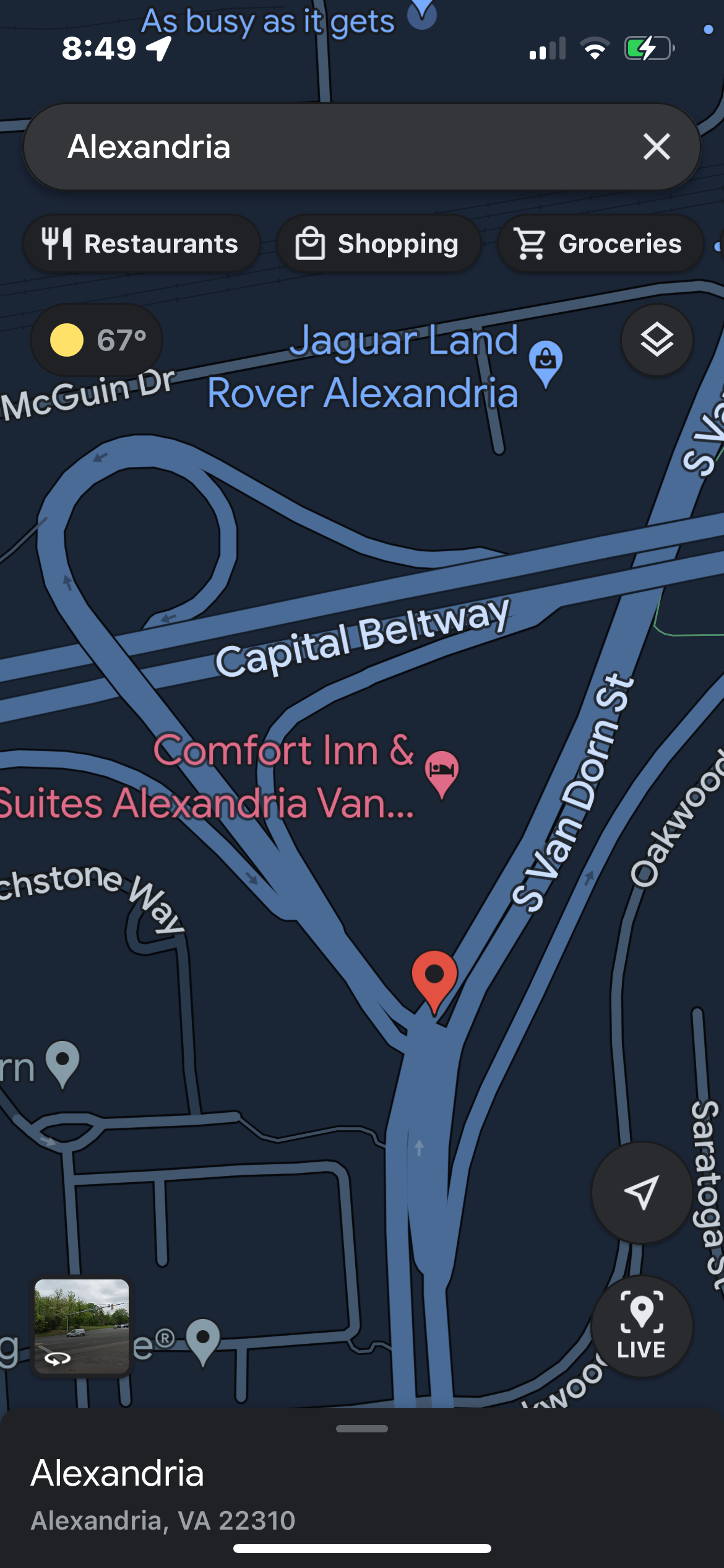
. I would never consider riding this stretch of road and feel sorry for any non-local who would find themselves there. 

This isn’t the first time that a route has taken me down a sketchy stretch of road. A similar thing happened to me at the beach over the summer where I was pointed down a straight, fast, 2-lane highway with no shoulder. 

Maybe some of these questionable routes were created with group rides in mind (strength in numbers and all), but I wonder if some aren’t drawn by bots. In any case, I’m using other resources to guide my rides in unfamiliar territory.

CreakyCrank
Forum|alt.badge.img+25
  • Hub Powerhouse
  • September 10, 2022

I concur - I've had a similar experience in Pittsburgh (fortunately, I drove the route first, as I was skeptical of some of the roads, and decided it was not a route I would ride a bike on).  What I find interesting though, is that you can create your own route, and mark it with public visibility - yet, I can't find any place to search for "human generated" routes, that I would have some confidence that somebody created.  I can create a new route, see my saved routes that I have made, but I can't seem to search for routes others have made.  This seems like it would be a great feature - to have a searchable set of routes, created by other Strava athletes, and then they could be 'rated' by others that try them (and perhaps comment), so people would know of any issues on the route [hmm... prepares to hop over and suggest that feature] << be sure to vote for it - safety for all!!


Forum|alt.badge.img+2
  • Hub Rookie
  • September 10, 2022

Wonderful suggestion. But I must say, I’m much mood impressed that, as a cat, you can both drive *and ride a bicycle!


MattS_bsb
Superuser
Forum|alt.badge.img+22
  • Superuser
  • September 20, 2022

Judging by the cycling heatmaps around Van Dorn, it looks like quite a few riders are cutting over to Oakwood Rd to avoid that sketchy section at the on/off ramp for I-495.  Sometimes you have to fiddle with the options between "most popular" and "most direct", and even then you run the risk of generating a treacherous route.  I’ve found that the route algorithm doesn’t really know the meaning of “safe” because it’s not actually riding/running these areas, but, it can be taught.  If you use OpenStreetMaps (OSM) to mark various streets/roads/paths as open to pedestrians, bikes, or cars-only, when OSM pushes map database updates to STRAVA, routing will take those into account.  Granted this isn’t an immediate process, but it’s a more hands-on approach to improving the system.  I’ve been making OSM tweaks over the last year or so to the areas here around Virginia Beach and have seen some improvements in STRAVA routing.  Hope this was helpful.  Safe riding!


Forum|alt.badge.img+16
  • Superuser
  • October 8, 2022

Openstreetmap is the source for the Basemap and routing. The tags for roads include whether pedestrians and cycles (etc) can use the way.  If cycling / walking / running is forbidden (like UK motorways) this can be recorded (map error reporting on Strava also works via mapping enthusiasts) and Strava won’t route along roads tagged cycling=no.

Trickier if access is permitted and safety might be choice: I try hard to avoid cycling on most dual carriageways where I see lots of braver cyclists, but “most popular” routing often avoids busy roads where cycling is permitted, but less popular.


Forum|alt.badge.img+1
  • Hub Starter
  • June 21, 2023

This issue still exists. A few days ago Strava created a route for me that placed me on Interstate 80 in Truckee, CA for several miles! It's illegal to bike on i-80.


Forum|alt.badge.img+1
  • Hub Starter
  • June 21, 2023

There are countless times that I've built routes using the routing feature (with the popularity heatmap) and then I get to the real place, only to discover that that trail is permanently blocked/closed/private. It would be great to be able to flag trails on the fly (just like Apple or Google Maps) and then if a trail gets enough flags, it would be removed from the database.


Reply


Cookie policy

We use cookies to enhance and personalize your experience. If you accept, you agree to our full cookie policy. Learn more about our cookies.

 
Cookie settings