


Have trouble with inaccurate GPS data while recording your activities? See the information below to learn more about what bad GPS data is, why it happens, and how to prevent it.
- What is bad GPS data?
- Why does bad GPS data happen?
- Examples of bad GPS data
- How to fix bad GPS data
- How to prevent bad GPS data
What is bad GPS data?
We use the term "bad GPS data" to describe any circumstance where your GPS device records location (or other) data that does not accurately represent your activity. Bad GPS data can result in your activities on Strava having missing or extra distance recorded; segments not matched at all or recorded inaccurately; inaccurate elevation data; inaccurate achievements such as estimated best efforts; and more.
- Your device may have simply lost a connection to GPS satellites and did not record any data. Your Strava activity may be missing a map, show a straight line connecting your start and endpoints, or was automatically tagged as an indoor activity.
- Your device may have recorded GPS points that deviate from your true path. See the examples discussed in this article.
Why does bad GPS data happen?
There are many factors that contribute to the accuracy of your GPS data - and it's important to keep in mind that no data is perfect; in fact, there is some degree of error inherent in any GPS recording. Ignoring (for now) environmental factors, different devices have different qualities of GPS hardware and software - meaning that even if your device is working at its peak performance, there will always be a margin of error in the accuracy of its recording.
GPS works by connecting your device to a number of overhead satellites and very precisely measuring the amount of time it takes for a signal to travel between your device and the satellites. Because the speed at which the signal travels is known, the amount of time the signal is in transit allows your device to calculate the distance to each satellite. Since the position of each satellite is known, as well as the distance between those satellites and your GPS device, your position can be triangulated. More information can be found here.
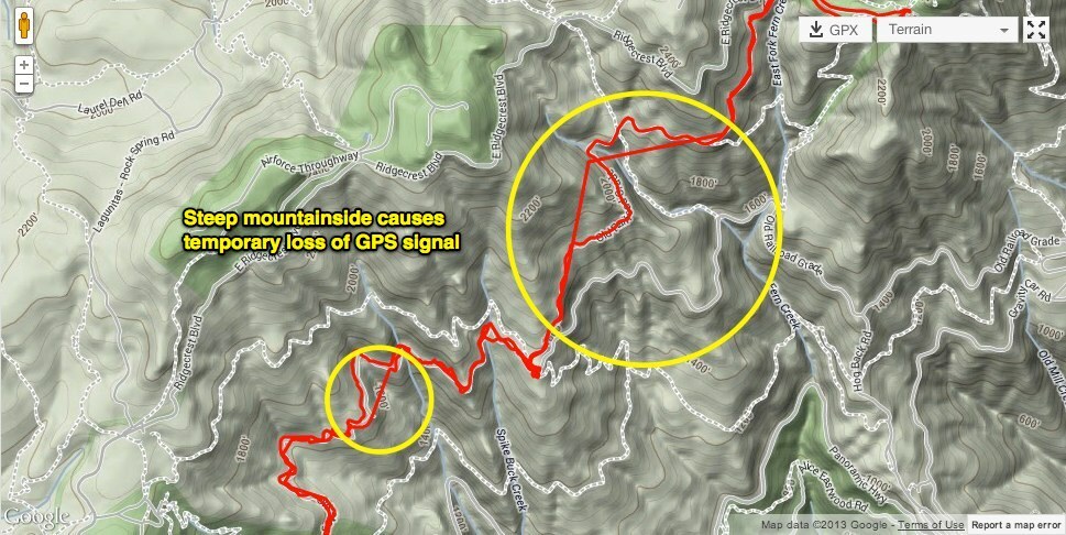
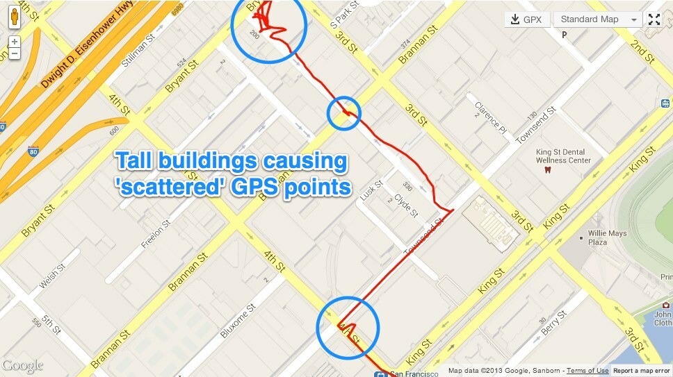
Because we're dealing with extremely fast signals requiring precise detection, any slight inaccuracy in the signal's reception, or disturbance to the signal itself, can translate to a significant dislocation of your reported position. Consequently, environmental factors such as dense trees, steep hillsides, tall buildings, or even heavy cloud cover can impact or even interrupt the travel of the GPS signal between your device and the satellites.
Examples of bad GPS data
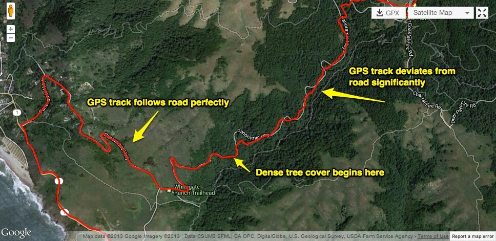
- GPS Drift: Below, you'll see a classic example of GPS drift where there's an area of dense, tall trees about a third of the way up the climb. As the activity below demonstrates, the GPS track follows the road with great accuracy until it enters the tree cover - at which point it begins to deviate from the road. However, you can see that the route generally follows the shape of the road; it does so with much less precision. Bad GPS data like this could cause your activity to report less distance than you actually traveled or not match segments that you would have otherwise matched.
- Lost GPS Signal: Environmental factors can often cause your GPS signal to be lost and some time later re-acquired. In cases like this, the pre-and post-signal-loss points will be treated just like any other two subsequent points (although more time has elapsed between them) and will be connected with a straight line. Cases of signal loss like this can cause your activity to report less distance than you actually traveled or not to match segments that you would have otherwise matched.
- GPS Bounce: Tall buildings can often cause a GPS signal to "bounce" on its way between your GPS device and the satellites, this adds extra distance - and therefore extra time - to your device's calculation of your position. This will often result in a "jumpy" GPS track as you see below. Bad GPS data like this can often cause your activity to report more distance than you actually traveled since each **bleep** and zag of your GPS track has to be accounted for with a straight line connecting them. It can, in turn, cause you to receive inaccurate achievements on your activity or miss segments that you would have otherwise matched.
How to fix bad GPS data
While Strava does its best to optimize our data analysis by ignoring the most obviously inaccurate data, in the end, we can only make the most out of the data provided to us from the GPS device. Put another way, when a device records bad GPS data, the only option that Strava has to improve it is to ignore portions of that bad data. Unfortunately, when, for whatever reason, a portion of your activity isn't recorded by GPS, it is not possible for us to "fill in" the missing data or "correct" the bad data. However, you do have a few good options to get credit for your efforts and manage the way that GPS data is represented by activities:
- If a segment didn't match your activity, but you think it should have - you can request that the Strava support team review and attempt to force that segment to match your ride or run. We cannot adjust your time on a segment, however. Here is more information on segment matching issues.
- You can, in some cases, correct the elevation data calculated for your activity. More information is in our elevation FAQs.
- You have the option to crop your activity to simply cut out the most affected parts of your activity if the bad GPS data occurred at the beginning or end of your ride or run. Here is some more information about the crop tool.
- You can create a manual activity to account for the lost mileage - although this may not count toward Strava Challenges and won't match to any segments. More information on how this feature works can be found here.
- If you were with a friend who recorded the activity with GPS, your friend can tap the Add Friend button on their activity detail page, which creates a shareable link they can send you. This will allow you to upload a copy of the activity as your own. More information on how this feature works can be found here.
How to prevent bad GPS data
Thankfully, there is more that can be done to prevent bad GPS data from being recorded than there is to repair it. As previously mentioned, different devices do simply have different qualities of GPS hardware, so although there are some tips and tricks that are device-specific, there are also some key practices that can help improve your GPS data quality regardless of what device you're using.
- Make sure your device is mounted/carried as high up and unobstructed as possible instead of buried deep in a pocket.
- Do your best to avoid environments that are always going to be problematic for a GPS signal, such as canyons, whether natural or man-made (think a city street lined by tall buildings), dense trees, etc.
- In many cases, it will help to give your device a minute or two while you have a clear view of the sky to fully acquire a signal before beginning your ride or run.
- Sometimes simply turning your device off and on again, or disabling and enabling GPS, will do the trick.
- As for specific devices, the manufacturer will always have the most up-to-date and relevant information, but we have some suggestions for troubleshooting for Android and iPhone.